Central Slovakia
Central Slovakia
Stredné Slovensko | |
|---|---|
Region | |
| Country | Slovakia |
| Area | |
• Total | 16,263 km2 (6,279 sq mi) |
| Population (2024)[2] | |
• Total | 1,301,530 |
| • Density | 80/km2 (210/sq mi) |
| GDP | |
| • Total | €24.452 billion (2023) |
| NUTS code | SK03 |
| HDI (2022) | 0.836[4] very high • 3rd |
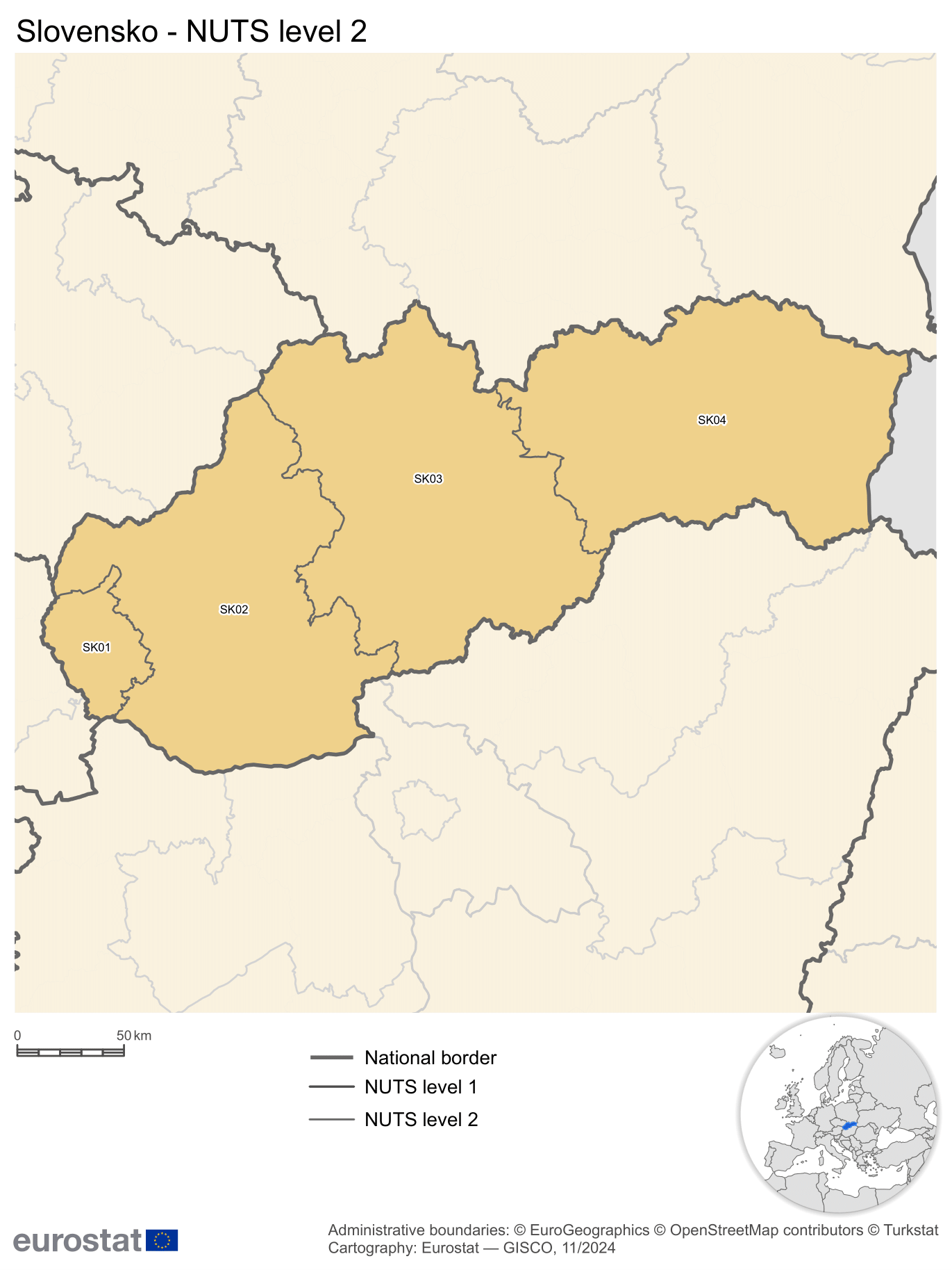
Central Slovakia (Slovak: Stredné Slovensko) is a subdivision of Slovakia as defined by the Nomenclature of Territorial Units for Statistics (NUTS). It is one of the four classified NUTS-2 statistical regions of Slovakia. The region incorporates the central parts of the country, and encompasses an area of 16,263 km2 (6,279 sq mi). It incorporates two kraje–Žilina, and Banská Bystrica. The region is home to more than 1.3 million inhabitants. Despite being the largest region of Slovakia by area, it is the second least populated after the Bratislava region.
Classification
The country of Slovakia is organized into 12 regions (kraje) for administrative purposes.[5] The Nomenclature of Territorial Units for Statistics (NUTS) organizes the country into four broader level sub-divisions.[6][7] These are classified as a NUTS-2 statistical regions of Slovakia, and incorporate one or more regions within it.[8][9] The regions form the NUTS-3 territorial units under them.[5]
Geography
Central Slovakia incorporates the central parts of the country excluding, encompassing an area of 16,263 km2 (6,279 sq mi).[1] The region is located in Central Europe, and is completely land locked as Slovakia does not have access to sea.[10] It shares land borders with Czechia and Poland in the north, and Hungary in the south. It is bordered by Western Slovakia on the west, and Eastern Slovakia on the east.[11] Most of the Central Slovakia is dominated by the Western Carpathians mountains.[12][13]
Sub-regions
Central Slovenia incorporates incorporates three kraje–kraje–Žilina, and Banská Bystrica.[8]
| Name[8] | Official Name[1] | NUTS code[8] | Area (km2)[1] | Population (2021)[14] |
|---|---|---|---|---|
| Žilina | Žilinsky kraj | SK031 | 6,801 km2 (2,626 sq mi) | 691,613 |
| Banská Bystrica | Banskobystricky kraj | SK032 | 9,454 km2 (3,650 sq mi) | 625,601 |
| Central Slovakia | Stredné Slovensko | SK03 | 16,263 km (10,105 mi) | 1,312,714 |
Demographics
|
| ||||||||||||||||||||||||
| Source: Census of Slovakia[15][14] | |||||||||||||||||||||||||
Central Slovakia had a population of over 1.3 million in 2024. Despite being the largest region of Slovakia by area, it is the second least populated after the Bratislava region.[1][2] While the region has a high Human Development Index, and is the second least developed region after Eastern Slovenia.[4] The population of the region has been shrinking since the late 2000s, similar to the other two large regions of Slovenia (Eastern and Western Slovenia).[2][15] The average of the resident population has been increasing, with increased life expectancy, decreased rate of birth, and exodus of young people to the capital region and abroad.[16]
References
- ^ a b c d e "Area by NUTS 3 regions - km2". Eurostat. Retrieved 1 June 2024.
- ^ a b c "Population on 1 January by NUTS 2 region". Eurostat. Retrieved 1 June 2024.
- ^ "EU regions by GDP, Eurostat". Eurostat. Retrieved 18 September 2023.
- ^ a b "Sub-national HDI - Area Database - Global Data Lab". Global datalab. Retrieved 1 June 2018.
- ^ a b "Regions of Slovakia". Slovakia.com. Retrieved 23 November 2016.
- ^ "NUTS classification". Eurostat. Retrieved 1 June 2024.
- ^ "Regions in the European Union: Nomenclature of territorial units for statistics" (PDF). European Commission. Archived from the original (PDF) on 21 February 2011. Retrieved 25 November 2012.
- ^ a b c d "NUTS regions". Eurostat. Retrieved 1 June 2024.
- ^ "Commission Regulation (EU) 2016/2066 of 21 November 2016 amending the annexes to Regulation (EC) No 1059/2003 of the European Parliament and of the Council on the establishment of a common classification of territorial units for statistics (NUTS)". EUR-Lex. Retrieved 3 February 2019.
- ^ "Slovakia". CIA World factbook. Retrieved 1 June 2024.
- ^ "NUTS Maps: Slovakia". Eurostat. Retrieved 1 June 2024.
- ^ "Terrain and topography of Slovakia". Earth site. Retrieved 1 June 2024.
- ^ Jan Kliment; Peter Turis; Monika Janišová (March 2016). "Taxa of vascular plants endemic to the Carpathian Mountains: Location and divisions of the Carpathians". Preslia. 88 (1): 19–76. Retrieved 1 June 2024.
- ^ a b "Census 2021 - Population - Basic results". Statistical Office of the Slovak Republic. 1 January 2021.
- ^ a b "Statistical lexikon of municipalities 1970-2011" (PDF). Statistical Office of the Slovak Republic (in Slovak). 1 January 2021.
- ^ Vojtech Kollár; Silvia Matúšová (July 2022). "Human Resources Development in the Solution of Regional Disparities in Slovakia". 8th International Scientific Conference: 211–225. doi:10.31410/ERAZ.2022.211.